Monday, March 25, 2013

The Maldives: A tale of two days (OR: Maldives is not about the land: or is it?)


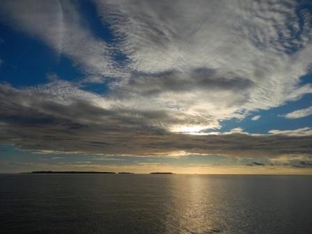
Two weeks at sea reminded us how much of our planet is water and sky, the latter taking on a presence that demanded attention and always provided scenes of extraordinary colour and varied cloud shapes: the beauty was often incredible.
We were, of course, looking forward to land again and are enjoying the opportunities to stop the boat and walk on terra firma; but there is not a lot of land in the Maldives!
Sometimes an island strip reveals the water-sky interface.
Sometimes it adds another focus to beauty already there.
 And what land there is, becomes used to the fullest….
Male, the capital city, filling all the space available on the island
Resorts need to build out on stilts for their accommodations.
  A few words about the Maldives, as it impacts on the life of cruising yachties: firstly, we need permission to anchor in certain areas and then, even though we live on the water, it IS all about the land for us – specifically, the sea floor, and what it offers for anchoring.

We need: a depth of 4 to 20 metres, good holding sand, no coral outcrops (bommies) or rocks to foul boat undersides or snare the anchor-chain.

The Maldives is made up of 26 atolls spread out N to S over 1000km; each atoll is made up of a ring of reef and islands, and there are 1192 coral islands in total (none higher than 3m above sea level). The atolls are each surrounded by reefs and the islands, too, are surrounded by their own reefs.

Yachting in this country is complicated: no anchoring outside the atolls (depths are hundreds of metres); difficult access into the atolls (they are surrounded by reefs, but with small passages); care required for sailing inside the atolls (many coral heads make it inadvisable to sail except in the best light, with a watch on the bow for bommies coming close to the surface); anchoring depths in the atolls are too deep for normal cruising yachts (about 40m), and off hundreds of islands no anchoring at all.
This chart, for example, shows an atoll we will reach in a few days: South Nilandhe. We will see little above the water: just the few tiny yellow circles (eg one in the south) which are islands; the rest of the green is all submerged reef… to be avoided, but not seen above water – good eyes and good visibility required to see the colour changes in the water. There are a few channels to get into the atoll, and when inside we must dodge all the reefs and bommies coming to the surface from about 50m below. We have information for only one possible anchorage (marked red) and hope the information is good, or we leave the atoll.

Anchoring for us is only possible in the shallowish sandy areas sometimes found near the islands. Sometimes you can get to the sandy areas, sometimes you cannot as the surrounding reef has no break. Sometimes the sandy areas are littered with bommies.

So this is what is important to a cruiser in the Maldives: accurate sailing notes that give GPS positions for channels through the reefs and also potential anchoring positions, depths and ground state. We have bought a booklet of these, and also have documents circulated via other yachties, from their experiences.
Also vital? Accurate charts on the boat (in our case, the electronic chart-plotter and paper charts) as we use them, along with depth sounder, for navigation.

We received our cruising permit (permissions) and set off with our reference notes to Ari Atoll, not previously visited.

Here is the story of two days.

Ari atoll has many easy entry channels through the outer reef: wonderful start. We neared a resort anchorage, for which we had anchoring GPS points in notes. The anchoring waypoint was wrong: the depth was totally out (too deep) and it was likely on coral (we would destroy nature and ourselves!). We phoned the resort and after much to-and-fro were given the welcome invitation to use their mooring buoy: heaven!!

We tied up and took ourselves to reception, where we were greeted, given a tour and invited to use the facilities – which we did, gratefully, and would invite all other yachties to go to Moofushi Island Resort.
How most guests get to Moofushi: by sea-plane taxi.
It is good to not have anchor chain snarling up in those dark areas.
 Leaving here, we had only 5nm to go to our next anchorage, so left at 9:30 am for a one-hour trip looking forward to a non-travelling day and a non-resort-based anchorage.

Our reference notes were wrong again: the island anchorage was… well, NOT do-able!

“No problem, let’s go to the next one”… off an island village; there is a long channel to reach it, but we have the GPS co-ordinates for the entry to the pass. These were wrong, and the three of us (two on bow, one on helm) could not find the entry. After about an hour we said:

“No problem, let’s go to the next one”… off a resort on Rangali Island, noted in the booklet to be welcoming. Nonetheless, we phoned for their permission and were asked to send mail giving our details. We did. About 5 phone calls and 8 e mails later, we established that they were receiving none of our mail (to two different addresses there, from two of ours); but anyway…. We were now there, and their harbour was empty, so in we went.

Anchor down, cool off in the water – and the security boat arrived, most decidedly without welcoming demeanour. Despite (we thought) reasoned discussion and a print-out of our several e-mails, and informing them that we did not need a room, just a night on anchor, we received a text message saying we were not allowed as “we are running with full occupancy”. We phoned (again); this time she admitted that we were a “security threat to our high-end clients”.

It was now 4:15pm and we had to leave, find the next anchorage and enter it safely: for which we need good visibility.

At 6pm, in fading light, we found the entry to the Maamagili channel : the notes were right, the start to the entry is denoted by two piles of rocks and a pole (fairly typical Maldives). But we still had to find our way in and then around the lagoon (to the recorded anchoring position) without mishap.

Fortunately a dhoni was exiting the channel at the time: placing waypoints on his moving radar print on our electronic chart we found the line of the channel and eased forward. The notes warned of bommies and raised ground to port so we went further in and turned to port after we saw a white buoy…. Aaaargh!!! The ground rose up alarmingly and the two ladies on bow yelled as engines were thrown in reverse. Please understand: the ladies are not usually slow to yell at the skipper (!): we could not see! Polarised glasses do not help at dusk…

So we eventually gave up trying to go to port and decided to just drop anchor at sunset, about 9h after we had set off for our “short-sailing” day. If this had not worked, we would have had to exit the atoll and spend the night at sea: not a bad option, and certainly less stressful than damaging the boat.
Anchoring at sunset is beautiful, but to be avoided if possible
 We were anchored in the main “industrial” section, with a dredger for company, and resort-headed (inquisitive) speedboats and dhonis ploughing a constant path around us.

Wonderfully easy to see deeper water when the sun is high, right? For our future reference, before leaving the next day we drove around the harbour and placed a track for a safe route (we would return here to get Sandy to the ferry).
Chart showing waypoint route for channel, our first anchorage on S side, and later track to better subsequent anchorage.
 When would the adventure provide us with less excitement and stress? We wished for that: especially Rolf and Irene, who can still hear and feel the experience of grounding on a reef from their previous Maldives stay…

The next day we set off for a prettier anchorage: the charts showed potential at a lagoon behind a reef. We approached it, did the trick of using moving dhoni radar print to get a passage track to follow, and moved towards the start of the channel. Two men on a small tender raced towards us from inside the lagoon saying STOP! We did (oh, no! Is this security sending us away again!?). But no: Ali, the skipper of the local resort catamaran, came on board and said that channel was too shallow for our draft, and kindly showed us a passage across the reef further up.
Ali advises on route through underwater reef: local knowledge is everything!
We tracked it…
Lagoon chart: track 16 was successful, but waypoint track (bottom left) Ali stopped us from entering... thankfully!
 …and have stayed here four days.  Four waypoints (besides those on the channel entries) show our anchorages. See the one apparently on the reef on the chart? Here is the chart with radar overlay:
Clearly the chart is shifted about 0.5nm out… this does not help, when navigating in the Maldives.

For now: we are currently at that boat icon - we have land! Good holding under the boat, no threatening underwater obstructions, it is easy to travel (in good light) to visit the local village at Digurah, the beach alongside us, the very welcoming Lux resort on Dhidhdhoofinolhu at the other end (all yachties: go to this resort for a warm welcome!), and there is superb snorkelling outside the extensive reef… underwater gardens and fish life in the Maldives are superb.
 A great place to spend a few days, work on the boat…. and plan our passages for the rest of the journey through the Maldives.


Thursday, March 14, 2013

Here we go on ocean crossings again: Phuket to the Maldives


Did it! Tick: here we are - Male, on North Male atoll of the Maldives, that is; having left Phuket, Thailand exactly two weeks earlier.
Celebrating the two flags
We previously did the Male – Phuket voyage in June 2010: a good but tough-ish trip, with a great additional pair of hands on board in Brian, but with strong SW monsoon weather in a fairly dreadful storm system that threw various challenges at us, like: keeping the boat from slewing sideways down large waves and avoiding the cargo ship that turned into us and, sick of being sodden and harnessed and shackled onto the helm in our foul-weather gear for two days, seeking refuge in Sumatra.

That provided background memories to this journey, which was done in reverse and in a different season, the NE monsoon season.

And what a different trip it was! We have never had such “good” weather over a two week period… meaning: in general, the winds were from the NE or E and gave us fair sailing and the sea state was mostly fairly gentle. But we had a range… there were periods (at the start and again at the end) of almost no wind and for these periods diesel had to be burned, and then there were squalls, gale-force at times, but their effect on the sea was short lived.
Many days created memories of sailing gently and slowly under the flying screecher sail, music sometimes playing, fish (dorado)committing  themselves to the braai, reading, scrabble, sleeping during off-watch periods (and sometimes during ‘on watch’…. No names…).

This was our journey: started on the east, headed west (the cross at the top of Sumatra is where we took refuge last time round) and you can see the boat icon now in the Maldives.

Phase 1 - Phuket to Nicobar Islands: we found most strange expanses of turbulent water that we could not explain and which were unsettling at first (and slowed us down); into phase 2 - west from there we experienced huge current against us and went south to find more favourable… which we did, so stayed on that line towards Sri Lanka enjoying the extra knot plus from the current.

The regular Ketoro crew are kept very busy with sail changes when the wind is not consistent in speed and direction, so the first week was very tiring indeed. One night, not wanting to wake Irene, the skipper (kind but misguided fellow) decided to furl in the screecher on his own as the winds were becoming too strong for that more-fragile sail. It did not work (euphemism for bad wrapping, getting knotted and top areas of sail billowing out). We then had to pull the sail down that night, strap it down to the deck, and deal with it in daylight (plus Sandy would then also be around to help).
Sandy and Rolf discuss strategy
Want great crew? Call Sandy! She now knows (as do we: a first for us too) how to unfurl / untangle a sail measuring more than 16m by 10m along the narrow and heaving deck of a yacht – along the deck and into the cockpit and out onto the deck the other side…. Oh, and then to re-furl the sail by hand (with her two assistants). An exercise not to be repeated…

At that stage, big weather in the southern hemisphere gave us strong swells coming broadside onto us from the south, and that soon gave rise to two mechanical issues… Rolf to the rescue, head down and bum up in the engine room and generator room again! Our new engine exhaust placement (for more quiet in the cockpit) took slamming surges of water and the pressure pushed water up into the system; if not identified soon enough, it would have entered the engine itself and that would have seized… aaargh!! Once identified (this little reference somewhat understates the stress, time and effort the problems caused) we knew in these rougher seas we would have to start each engine every two hours for a few minutes to expel any water that had accumulated in the wet exhaust systems, and it became a routine for the person on watch until the last few days when seas were flat.
Then we had an interesting tension-filled incident: a Sri Lankan fishing boat on the horizon spotted us and approached at speed and then chased us (our throttles full forward too) for miles. Unnerved by this first one, we later realised that they are not necessarily threatening us but seeking hand-outs (cigarettes and alcohol).
 However, whatever our approach to such enriching cultural interchanges, we cannot have them coming close and bumping our boat (fragile plastic fantastic vs massive fishing boat: no prizes for guessing who spends the next year doing expensive repairs) and Rolf worked on his cold and unapproachable side.
 Also finding that the frame of a paintball gun (without the bulbous bits) being allowed to be seen while secreted under a towel immediately cooled the enthusiasm of the pursuers.
Normal life continues: re-fuelling
 Back to the journey and phase 3: it was at this stage that we decided to turn south and limit exposure to Sri Lankan fishermen! Just south of Sri Lanka runs the shipping channel, surprisingly busy with ships thrumming their paths between the Red Sea and Malacca Straits. The crossing was straight-forward, done at approximately 90 degrees to the shipping with full sails and high revs; it took about 5 hours and went with no hitches. Our AIS identifies ships, their course and speed and warns of potential collisions, and calling them up by radio when necessary was always met with friendliness and cooperation. (Our AIS also identifies us to them: wish we had had THAT on our first crossing in 2010!)
Normal life continues: washing day
Continuing south, we only turned west into the last leg to head for the Maldives when we thought we would be sufficiently south of SL and reasonably clear of the fishing boats (which is ridiculous, considering we know that they are chased away from Chagos waters: they travel huge distances). This plan worked fairly well, and the dreaded experience of fishing boats at night proved, mostly, unfounded… boats were far apart and little course change was required. However, on one night we had about 9 boats in a relatively small area in a few hours. Dodgems on the sea with boats that are built in timber (and make poor radar targets) and do not have appropriate navigational lights and in some cases are dragging nets is not fun, and one incident in particular is best forgotten, with him changing course in front of us, his spotlight waving frantically, us trying to avoid him and running along the deck with our spotlight trained on the water to find those offending nets. All ended well.

The last section, closing on our destination in the setting sun initially provided gentle but workable winds until they died in the last two days.
Sandy toasts a good day
There is one good thing about no wind: when engines go off, the boat simply stops. And the sea was so flat that we simply leapt in: the water is an astoundingly beautiful royal blue, and the clarity so fantastic that you feel the ocean bottom, about  4km below you, should be visible! (We confess that we did not completely let go of the boat.) Of course, we also found it fun doing this on other days, when the boat was moving slowly…. Holding tight to the swim-ladder and dragging through the water!
At this time there was no rain, hence no clouds; the moon had waned to a tiny sliver… and the sky was a startling black backdrop to a spectacular star vista, occasionally rewarding us with shooting stars. Simultaneously, there was considerable bio-luminesence and Ketoro seemed to be floating on sparkling white cushions.

The biggest highlights: dolphins – playing at the bows, turning to look at us, leaping out of the water nearby and flinging their bodies around in joyful abandon. They visited us many times.
And of course: spectacular sunrises and sunsets. With no land to distract you, you are very aware of the immensity and beauty of the sky, its clouds, and all its colours and faces. Plus, its colours are repeated in the water below, so there is nothing to beat a sunrise or sunset at sea!

Sandy, great friend, turns out to be great crew too: Rolf says she is a keeper! Oh: also a great photographer… many of these pics are hers. Sharing watches and galley duties and general boat chores with a third person awards many more rest hours to us, and makes a passaging experience so much more pleasant. We came into the Maldives less exhausted than imagined after a two-week ocean crossing… and it helped as we had to wait and drift around aimlessly in anticipation of the officialdom that arrived to make our stay legal.
Here they are, we are now legal, we are ready to cruise the Maldives!

Saturday, February 23, 2013

Here we go again


We are off again… crossing that ocean to get back to South Africa, with the intention of using it as a stepping stone to South America. But of course, with our arrival in SA only about nine months from now, South America is a long way off and those plans are ephemeral at best.

What! 9 months to get to SA? So to explain ourselves here is the picture of the voyage, with a brief description.
 There are 4 main legs to the route we have chosen across the Indian Ocean: Phuket to the Maldives, Maldives to Chagos, Chagos to Mauritius and finally Mauritius to SA.

Leg 1 is timed to use the winds of the NE monsoon season (blowing from the NE), which hopefully will mean that in general we will not get wind “on the nose” that we have to bash into. This leg will be done in the last week of Feb / first two weeks in March.

This grib chart (below) shows the weather in that first leg predicted for 24 February: wind indicated by small arrows, blue patches show rain. The cursor (showing where we are going, roughly) and associated detail on the left clearly shows almost no wind in that area…
for situations like this, we have made provision….
Yes, an additional 20 jerry cans of diesel, secured along the back walkway and in lockers, which we are hoping NOT to use!

On the other hand, we see a cyclone developing SW of Sumatra. This system draws in all the wind from elsewhere, and we may end up with absolutely nothing; on the other hand, it could move up and give us wind… but it may just be in the wrong direction and it may just be uncomfortably strong. 

The prediction for next Thursday however is this:
We will be at the red dot, approximately: reasonable winds but very, very wet. Once we are out there, of course, we just do the best we can with what we find.

Leg 2, Maldives to Chagos, is short (about 3 days) and generally easy. To be done after a month travelling down from mid-Maldives to the southernmost atoll, enjoying just cruising.

Leg 3 takes us to Mauritius. We will try to go via Rodrigues, but may not get there if the winds have too much of a South component.

On 17 Feb, this was the weather in that general area of the Indian Ocean:
 UGH! The detail shows 60knot winds in a cyclone just off Madagascar, and a storm front approaching from SA…. And they both moved towards Mauritius: You do NOT want to be in that ocean!

This 3rd leg therefore cannot be done before the cyclone season south of the equator (and over Mauritius) has ended, hopefully by mid May. The timing of legs 1 and 3 dictate a stay in Chagos, but BIOT (British India Ocean Territories) only provides a one-month permit to visit Chagos, sometimes making it difficult for sailors if there is an unfavourable weather system ahead of them and they need refuge.

Leg 4 (Mauritius to SA, after hopefully a quick visit to Reunion) should not be done while there is still chance of big storms coming round the cape and up the east side of SA, therefore cannot be undertaken before about October, which dictates a long stay in Mauritius.

So. Weather dictates our progress, but we look forward to the forced stop-overs in Maldives, Chagos and Mauritius as opportunities to explore and in some cases have friends and family do some exploring with us.

Our hope is that we are NOT dictated to by boat problems, and at this stage we believe Ketoro to be sea-worthy. A complete set of new house batteries, new starter motor and regulator, all less than a week before departure, amongst many other mechanical interventions, will hopefully ensure that.

This work was done at Yacht Haven Marina, far north in Phuket, and this was Rolf’s view from half-way up the mast when Irene winched him up there to fix the fore-deck light (for night-time sail changes and deck work at sea) and install a new horn.

And this was Irene’s zoomed-in view of Rolf:
At this stage his bum was really sore and he was using his feet and toes to shift weight (as is monkeys’ wont): my request to send down the bag to hoist up the camera and remain up there, get creative and photograph his environs was somewhat growled at…!

We have also worked hard to fill Ketoro with provisions… if you were to come on board, you would probably laugh and roll your eyes, particularly at this sight:
This was the forward cabin, just starting to take shape as a storeroom, but already providing essential needs: the box of red wine centre back, the drinks cans dotted around (these supplement those at the bottom of all the other lockers), the spare water pump and white bag which contains spare toilet macerator, fan blasting air into the jam-packed back locker (found mould, didn’t we!?) and…. Drum roll… huge bags of corn flakes and coco pops!! Ok, so our insistence on kids’ cereals is shooting ourselves in the foot in terms of storage, but cereal people are cereal people and they will make a plan to get their coco pops (won’t they, Rolf!?)

Our first provisioning trip to Macro rewarded us with 3 huge trolleys and a till slip that was longer than Irene is tall.
Rolf with part of our first provisioning-trip supplies
The stuff all had to go somewhere. While we unpacked lockers to put layers of tins and cans at the base and then repack, we found that our system of storage has until now been pretty erratic. So started a major “spring clean”. That means storage of foodstuff, medicines, electricals, tools, adhesives…. You name it.

And of course that spring clean found the mould in the locker above. This is a very dry deep-storage locker: duvets, sleeping bags, hiking boots, extra pillows etc have been safe there for 3 years. Further investigation of the mould revealed…. Aaaargh! Water! Saturated sleeping bags! Moulded boots! The finger-tip taste test revealed salt. Happily, it was nothing more than a leak in the water pipes that feed through this locker to cool the generator and 24 hours later (and a boat festooned with dozens of odd drying items and Rolfs work on leak identification and repair and subsequent drying out of locker)… the deep-storage dry locker was good to go!

Well, so are we.

So: a quick trip to lovely Phuket town
to enjoy the contrasts provided by newly-renovated old buildings
and a quick reminder of the great market food stalls
Bye for now! We will upload the next blog when we are in the Maldives, but until then you can follow our progress across the ocean by clicking on the link on the right.

There is a huge ocean out there, and it is an extraordinary privilege to have such close contact with it. It is at times exceptionally beautiful, at times not; at times benevolent, at times definitely not so. We will be well - we will be sailing! Enjoying the good and getting through the less pleasant, we will make the most of the experience of the open ocean again. 

Tuesday, February 19, 2013

On board our boat

We have just had Mark, Livi and little Blake on board, so of course we would like to write about it and thought, for those of our friends who have not yet visited us, that we would like to give them a picture of what it is like to live on board our boat.

And since we took the family down the magnificent west coast of Phuket then up into Phang Nga Bay, we would be guided by the photos and make it a picture-story.

So, of course, we went to the photographs to use them as a base and weave the tale around them. But… well, this is pretty ridiculous!! Magnificent scenic shots? Sunsets? No… All the photographs are of a baby!

So now we have to confess that this tale of life on Ketoro is from the perspective of a 6-month old; future visitors, please be not afraid: the boat caters for adult visitors quite comfortably, and you will not, for example, have to…

Bath in the galley sink on the first night, after your late flight;
We will provide other lovely bathing circumstances for you;
You will not be restricted in your movement around the boat (but we can make it safe for you too…).
You may do a bit of driving,
You will be treated to dinghy rides, and if you examine your circumstances we hope you will be at peace with it all!
(but we are not sure if, for you, we will stretch to lounger up front in the dinghy, with cold-pack for your back and parasol for shade);

And we will provide the wherewithal for all your other needs (so what is wrong with these teethers?)

Hopefully the background of the photos show adequately the crystal-clear water, beautiful scenery and lovely eateries which we try to show our visitors…. Whether or not they are able to appreciate it!

Of course, on board our boat there will invariably be work needing to be done; in this case, amongst others, Mark was required to help Rolf change props underwater,
and the boys spent many hours in the port engine-room.
This means they spent many hours under the port bunk in the cabin, which of course means that on board our boat it is not always a certainty that your cabin will be entirely yours for the duration of your stay!

Along with tales of boats at sea, sometimes there are unfortunate stories to be narrated of marine creatures defending their territory from us, the invaders. This time it was Irene who had an unfortunate encounter: with a jellyfish, or rather: the extremely long tentacle of one. On board, we did the best we could to denature the toxin initially with vinegar and heat, but it turned out we simply did not have adequate pain killers or other meds to deal with the symptoms brought about by the toxins that affected nerves, muscles and joints. We are, however, blessed to have friends on shore, and JJ came to the rescue with a longtail boat and then his car to whisk us away to hospital where they addressed the inadequacies of the med kit on Ketoro!

During the final week of Blake’s stay, we watched the stars and nightly saw the new moon begin to fill…
Bitter-sweet for us, for at the next full moon we will be on our boat, sailing away from Thailand finally.

So you will have to come and join us at our next destination… come on board our boat, and claim your own Ketoro cap!
In fact, if you come to Mauritius but are worried that you have no sea legs, rest assured: the net to surround the boat lies in wait for the visit of two perhaps newly-walking tots, and will be there for you too!