Between Phuket Island and the Thailand mainland lies Phang Nga Bay, an extensive section
of which is Marine National Park. It is an exceptionally beautiful area,
with karst mountain island structures, limestone cliffs with
caves, collapsed-roof cave systems (which form “hongs”, Thai for “room”) and
archaeological sites.
It is a
shallow bay with over 40 islands and many mangrove species. We read (Wikipedia)
that just 10 000 years ago, when sea levels were lower, one could walk
from Phuket to Krabi…. but now you get around on this section of the
Andaman Sea by boat.
So, of course, if you a) have a boat and b) have time on
your hands and c) are in Phuket… well, it’s a no-brainer, really! We have been
in and out of the bay often, shared it with family and friends who have loved
it, but now it was time for a tour, seeing old favourites and venturing into
less travelled territories. This was our route:
 Here is a (mostly) pictorial account of this very
picturesque bay, as we enjoyed it. (Stop numbers are given for the route. One
or two stops are not pictured here, where they have been covered in previous
blogs.)
Here is a (mostly) pictorial account of this very
picturesque bay, as we enjoyed it. (Stop numbers are given for the route. One
or two stops are not pictured here, where they have been covered in previous
blogs.)

Ko Phanak (stops
2,6)
 |
| Convoluted lagoon in the north: a great place for a sundowner dinghy ride. |
 |
| The view north from Phanak, whilst cooling off under the boat. |
Now it was time to head north, further into the bay.
Ko Daeng (stop 3)
Given that the
bay was walkable not so long ago, it is of course very shallow. This has
implications for boats, if the crew do not want to become landlubbers,
inadvertently! So, the further north you venture, the shallower it becomes and
the slower you go. There are some channels but in the end, you must simply be
cautious… and read and interpret the tide tables carefully, watch the depth and
be sceptical of the navigation charts.
 |
| Heading north to Ko Daeng. |
 |
Anchored under stunning Ko Daeng cliffs.
|
From our anchorage, our dinghy ferried us around in our
explorations...
 |
| Up tributaries in the mangroves: only at high tide, or risk getting stranded! |
 |
| To tiny beaches (where there always seems to be salvage…) |
 |
| … a fallen tree to shelter us from the rain. |
Sights and sounds of the bay:
 |
| Quiet solitude in a misty cool dawn. |
But early fishermen on their longtails shatter the silence.
The magnificent Ko Daeng cliffs are shaped like a parabola: and Ketoro appeared
to be anchored at the focal point of the reflected sound waves!
 |
| It is not long before the cool will give way to fierce heat. |
Sunrise, looking towards one of the most famous islands, James Bond Island: a needle-shaped limestone rock in the sea, featured in "The Man with the Golden Gun".
Ko Thalu and Ko Thalu
Nok / Raya (stop 4)
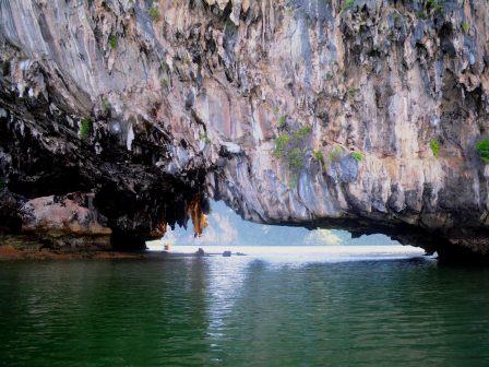
A short distance further north, we found Ko Thalu, a rock island with
a tunnel cave through the base.

These fishing nets have disconcertingly small holes, one
result being that many tiny, dead fish are tossed back into the sea… and an
even worse result being the impact this must surely have on fishing in the bay
in general.
Further east, Ko Thalu Nok also has a tunnel through the
base; this is big enough to allow dozens of kayaks to navigate it
simultaneously – as a consequence many tour boats go there, and the sounds of
Phang Nga Bay are different there!
Ko Khai (stop 5)

 |
| This beautiful little rock island has a lovely tiny beach with a view |
 |
And stunning overhanging structures with stalactites
|
 |
| which, on clambering up, |
 |
| proves to be a marvellous balcony |
 |
| that leads to stalactite falls and rocks in beautiful hues. |
We left Ko Khai to head to
Ko Naka (stop 7)
It was time to see friends again, and what better way than a
“braai” on the beach? (For our non-SA friends: this is a BBQ!)

On a blisteringly hot day, Ketoro rafted up against another
catamaran

So…Did we tell you that the bay is shallow in many areas!?
Getting to and from shore at low tides in the dinghy is tricky…

but not with our “Ketoro Depthometer” – a stick from Chagos
that lives in our dinghy for just such opportunities to show its worth! This
was Irene’s Chagos “salvage”, and it stands proud alongside Rolf’s Richards Bay
plank and other Phang Nga Bay planks now at home on the boat…
Ko Ku Du (stop 8)
A favourite anchorage between two islands, there are two
tiny beaches and a beautiful lagoon, and sheer beauty to enjoy on every face of
the island in a dinghy “circumnavigation”.

Ko Yao Noi: Ao Muang
Paradise Beach Resort (stop 10)
Meeting up with friends on their boat one evening, we
decided it was time for a meal on shore and the use of a resort pool. (Life is
tough). So off we went to a larger island, Ko Yao Noi.
Venturing on shore, we found cold beer, delicious food and a
lovely cold pool… And then we found that the tide was out and our dinghies
were high and dry!

Did we mention the resort loungers? They were an
exceptionally comfortable place from which to watch the waters slowly rise
until we could go home again!
Khlong Marui / Khlong
Pak Lao (stop 11)
It was time to venture further north than we had been
before, to explore the khlongs.
There is an extensive wetland area of mangroves in the north
of the bay. The khlongs are “rivers” that wind their way through the mangroves
and form ‘less-shallow’ channels. As we went slowly forward in the channels, we
put a track on our chartplotter to help us find the same route out again when
we returned… and in some cases to know where NOT to go when we returned, those
being the places where depth dropped dramatically, associated with a robust
gears-rapidly-to-reverse strategy and a skull-and-crossbones icon being placed
on that position!
 |
| Sunset on Khlong Marui |
We anchored as deep into the surprisingly broad Khlong Marui
as we dared, and dinghied down a tributary, Khlong Pak Lao. The only other
people about were a few fishermen in their longtails, who we saw scoot down the
more narrow waterways and simply disappear from view into their homes hidden
amongst the low mangrove trees.

Khlong Pak Lao meanders between lovely tall islands and then
we forayed down much smaller tributaries off this khlong to find some wonderful
places…
 |
| Old information poster at ancient cave entrance. |


 |
| Stalactites and "rock falls" were again plentiful and very lovely. |
It is not apparent from the photos, but the water up here is
awfully muddy and definitely not to be jumped into. The heat was absolutely
intense and there is no respite: not from the water around the boat, nor from
boat water: this is limited as our tank is fairly small and we could not run
the water-maker in the khlong water; it is too dirty and will clog the filters.
We were surprised at the strength of the tidal race: we were
here at springs and the depth difference was about 2.8m; while on anchor the
log showed a speed of 3 knots! With a good holding anchor, we did not worry but
still there was a lack of sleep…. Because of all the noises made by various
parts and lines of the boat that we could not identify that were rattling and
resonating and challenging our interpretation skills!
It was an incredibly uncomfortable few days -but we would
not have missed it for the world. A different, quiet, remote, interesting part
of the bay of which we have great memories.
Ko Chong Lat and Ko Khlui
(stops 12, 13)
Heading back south, down into the bay, there is a lovely
anchorage at Chong Lat Island that is surrounded by tall land masses and hence protected
in all weather conditions. Around the shallow curved edge on one side sits a
row of small wooden houses that appear to be fish farms, and other than that
there are lovely rocks soaring out of the water with steep sides… and rushing
tidal water that churns up the mud many metres below to give swirling
mud-patterns around the boat.

The waters just south of here hold many dangerous areas for yachts, with
rocks just below the surface, but these are marked with posts, and of course
such irregular underwater surfaces provide good fishing grounds… or they must
do, if the number of fishing couples in longtails is anything to go by.

These fishermen were incredibly friendly, shouting
greetings, (selling us their most delicious prawns, of course)…. And one team
sat quietly at night, their flashing anchor light in tandem with ours, and
listened to our classical music touching the quiet. When we switched off, they
left… but returned the following night!
 |
| Net repair on the tiny beach near us. |
 |
| A home drives past. |
 |
| Leaving the area. |
Krabi (stops 15,
16)

A bay framed on three sides by steep cliffs, with white
beach and clear sea, it is only accessible by boat... so longtails are the
preferred form of transport and give a very typical Thai picture!

Some of the upmarket resorts provide their own boat transfer
service, and those coming in on the east side have a problem at low tides....

Bet they never told the guests they would be transferred to
shore by tractor-and-trailer!
Krabi is famous for its rock-climbing: these cliffs must be
a climber’s dream, and several organisations appear to give excellent service
to novices while experts are spoiled for choice in individual climbs.


As well as the beach/swim/climb/kayak fun, there are plenty
of places to eat, get massages, and have your hair braided: not all of them of
such rustic appearance (and with healthy huge plants growing on the roof)!

Friends from Phuket came to visit. It was JJ’s birthday, so
we sailed from Krabi to the “Chicken Island”...

Walked the sand spit between the two (which is too deep at high
tides and a completely exposed beach at low tide).


Back in Ao Chalong,
Phuket (stop 19)
When we first arrived in Thailand, 2 ½ years ago, we came
into Ao (Bay) Chalong in Phuket, and it will be from here that we clear out in
February to return across the Indian Ocean.
Good friends were on their boat here, so it was catch-up
time again: always a pleasure when yachties’ plans overlap. Chalong Bay has
seen us a few times, and it showed us a very good face: wonderful new dinghy
dock (never mind that it is a failed marina for big boats...), plenty of
mooring buoys (so we don’t need to drop anchor and have our chain eroded away
by the tin in the water here: this was a tin mining area.)
Mostly, it is a real pleasure to see the Big Buddha on the
hill, this time peeking through clouds and seemingly with halo!

Of course, Phang Nga Bay is so lovely, and cruising around
here is so easy, that… as well as endless longtails and ferries with tourists,
there are many charter boats: yachts that have been chartered for a week or so
by groups of friends who have enormous fun in an easy cruising environment.
Many of the skippers of these boats are no doubt experienced sailors, but the
tales we hear of their lapses and sometimes incompetence are astounding; … and
we have witnessed several.
For example: anchored in a big, muddy, open bay, a boat came
in late afternoon and anchored alongside us; the anchoring process took a
surprisingly short time before celebrations and swimming commenced. Conditions
were very gentle. Later that night, we were aware that they had gone very
quiet, and used the torch to find them. Nope. Gone. We were surprised that
people would move anchorage in the dark. But then we heard bedlam way off from
us and realised (obviously only just after they had) that they had dragged
anchor and were heading out of the bay, backing onto a small island. They
started their engines and came back in, this time anchoring alongside us in the
dark: a concern. We listened to the chain going out: very little – maybe
10-15m. We watched to see them set the anchor: no. We knew it would be a long
and worrying night for us… but the wind and tide would carry them away from us,
so all was well. The next morning? They were not where they had started…
And for example… A
friend who is employed by a charter company to maintain the fleet describes one
of the most common problems as being blocked heads (toilets). Well, one morning
in Krabi we assumed this must have been the problem on board the charter boat
alongside us as we watched a man hold the handles of the steps, hang his bottom
over the edge (thighs parallel to sea)... and go. Definitely no pictures of
this one: save you the spectacle…
And then: this boat dropped anchor with full mainsail up,
near us in the channel between the two steep islands of Ko Ku Du (stop 8). The whole
crew then jumped into their dinghy and set off to tour the island, leaving the
yacht and its hoisted sail.
 |
| No, really, he IS anchored behind us! |
We watched the unattended boat sail around its anchor....
and were grateful for calm weather and space between us!
Home is now in Yacht Haven Marina (stop 21), where we will
leave the boat to make a grand trip… to see grandbabies for Christmas! (Oh, and
also their parents….)